New License Plate Design Unveiled for 2016

SD Standard Plate 2016 webNew 2016 South Dakota license plate design unveiled

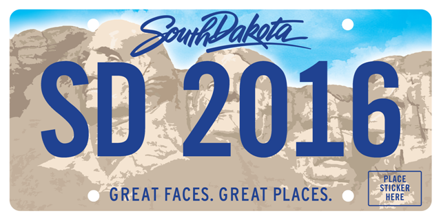
PIERRE, S.D., — An image of the new license plate design for the 2016 license plate reissue was unveiled by the South Dakota Department of Revenue, Motor Vehicle Division.

The new license plates will be issued beginning January 1, 2016.

The standard license plates currently identifying South Dakota motor vehicles have been in use since 2006. The plates are losing reflectivity, becoming damaged and suffering other readability problems.

The 2016 reissue will add up to approximately 1.5 million non-commercial vehicle and motorcycle plates consisting of the standard plate, the emblem plate, personalized plates, amateur radio, low-speed vehicles and the commercial radio plate.

The design was a cooperative effort between Gov. Daugaard, the Department of Revenue Motor Vehicle Division and the South Dakota Department of Tourism and reflects a partnership in promoting South Dakota.

The license plates will continue to be made at Pheasantland Industries located in the South Dakota State Penitentiary in Sioux Falls, S.D.

Fall River & Oglala Lakota County residents can renew their annual motor vehicle registration at the Fall River & Oglala LakotaTreasurer’s office in Hot Springs, at a self-service terminal (throughout the state) or from their Motor Vehicle customer portal at https://MySDCars.sd.gov.   Those who do so after Jan. 1, 2016, will receive the new license plates.

Fall River/Oglala Lakota County Treasurer – Kelli Rhoe (605) 745-5145

Why Be at Market Value?

State law requires that a county’s sales fall within 85-100% of market value.  The state ensures compliance with this by controlling the ‘state factor’.  The state factor is the third portion of the equation that determines tax values.

The formula for taxes is as follows:

Assessed Value   x   State Factor   x    Mill Levy    =    Taxes

Because the formula involves only multiplication an increase in any one of these numbers can increase the taxes if another of the numbers does not decrease in proportion.  The state factor is determined by how close we are to ‘full market’.  When we are closer to market our state factor is lower, when we are farther from market our state factor is higher. (See the examples of this in the table below)

County Sales Ratio

State Factor

100%

85%

95%

89%

90%

94%

85%

100%


There are only two state factors given to each county, one for agricultural properties and one for non-agricultural.  This means that one area of the county being under assessed can affect the tax value of everyone else.  If for example we had two towns in our county; Town A was assessed at market value while Town B was under assessed.  The properties in Town A should have a 85% factor for being at market value but because Town B is under assessed their sales bring the county’s sales ratio down.  So instead of a 85% factor the state gives a 94% factor, this means that Town A properties will see a 9% increase in their taxes even though their assessed values and mill levies remained the same.

Why are the percentages different between the classes?

AG classed property has the lowest mill levy, OO is next, and NA has the highest mill levy.  The increases between these mills is entirely located in the school districts portion of the mill levy. All other entities (county, fire, etc) charge the same mill to everyone regardless of class.


For example:

Two neighbors both have a house valued at $55,000

The one lives in his home and therefore is an owner occupied (OO) property. His yearly taxes are $1,200.

The second rents his property and is therefore classed as Non-ag (NA). His yearly taxes are $1,500.

Now remember, they both have the same assessed value.  The city’s mill levy is the same for everyone regardless of class, therefore they both pay $300 to the city. That is 25% of his total taxes for the first neighbor and 20% of his total taxes for the second neighbor.  The percentages look smaller but they are actually paying the same amount.  This will be the same for all the mill levy entities except the school.

The school mill levy is lowest for AG, then OO, and highest for NA. So neighbor one, who has owner-occupied (OO), is paying $450 to the school (37.5%), while neighbor two, who is not owner-occupied (NA), is paying $750 to the school (50%).


Return to post “Where are my taxes going?”

How to find your Taxing District or Property Class

taxbill2Your taxing district is listed on your tax bill.  Look at the upper right side of the page. You will see a block of text listing the city/township, additions, school district, and tax district.  In the tax district line the number after the TD is your taxing district. (This is also the number after the ‘D’ at the end of the line). See the image to the left.


assessment2Your class can be found on your assessment notice for last year.  Each property on your assessment notice is listed with a Parcel Number followed by the School District followed by one of these abbreviations: AG, OO, or NA.  See image to the left.  AG classed property has the lowest mill levy, OO is next, and NA has the highest mill levy.  The increases between these mills is entirely located in the school district’s portion of the mill levy. All other entities (county, fire, etc) charge the same mill to everyone regardless of class.

Return to “Where are my taxes going?” post.

Election Information – June 3rd, 2014

ELECTION RESULTS

Don’t Forget to Vote!

Information:
Polling Places
Voter Identification
Hot Springs City Wards Map
Edgemont City Wards Map
County Precinct Map -note that Limestone has been renamed “Oelrichs Area”

Sample Ballots